

About the Project
The DakE-Project aims to build a high-resolution observational network east of Dakar to observe mesoscale convective systems at near real time. The collected data is expected to help improve the understanding of the formation and decay of mesoscale convective systems and to assess the risk of extreme thunderstorm events.
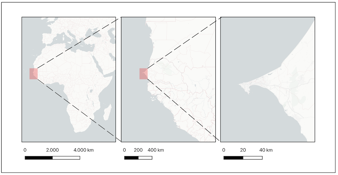
The Study Region
The study region, Senegal, is located in a transitional zone between a more humid climate in the south and the dry, hot climate of the Sahara Desert in the north1. This thermodynamical gradient forms the basis for the development of the West African Monsoon (WAM), one of the three main monsoon systems in the tropics, which dominates the climate in Senegal. The WAM is driven by the thermodynamic gradient on the large scale between the cooler, wetter conditions over the Atlantic to the southwest and the hot, dry conditions over the Sahara to the north. This shows that, in this monsoon climatic system the land, the ocean and the atmosphere are coupled. Variations in the monsoon can determine whether the region has enough, too much or too little rainfall2. The Sahel region is already experiencing more extreme weather meaning longer dry periods and heavier precipitation events with an altered frequency. In the Sahel region, 90 % of these intense rainfall events are caused by mesoscale convective systems (MCS)3. In Dakar, people living in informal settlements built in flood-prone areas are at increased risk of flash floods4 caused by sudden, intense thunderstorms. Weather and climate play a central role in food production, water resources, health and various economic sectors, such as fisheries and energy production in tropical West Africa5.
References:
1. Fall, S., Niyogi, D., & Semazzi, F. H. (2006). Analysis of mean climate conditions in Senegal (1971–98). Earth Interactions, 10(5), 1-40.
2,5. TParker, D. J., & Diop-Kane, M. (Eds.). (2017). Meteorology of tropical West Africa: The forecasters' handbook. John Wiley & Sons.
3. Mathon, V., Laurent, H., & Lebel, T. (2002). Mesoscale convective system rainfall in the Sahel. Journal of Applied Meteorology and Climatology, 41(11), 1081-1092.
4. Cissé, O., & Sèye, M. (2016). Flooding in the suburbs of Dakar: impacts on the assets and adaptation strategies of households or communities. Environment and Urbanization, 28(1), 183-204.
The DakE-Station Network
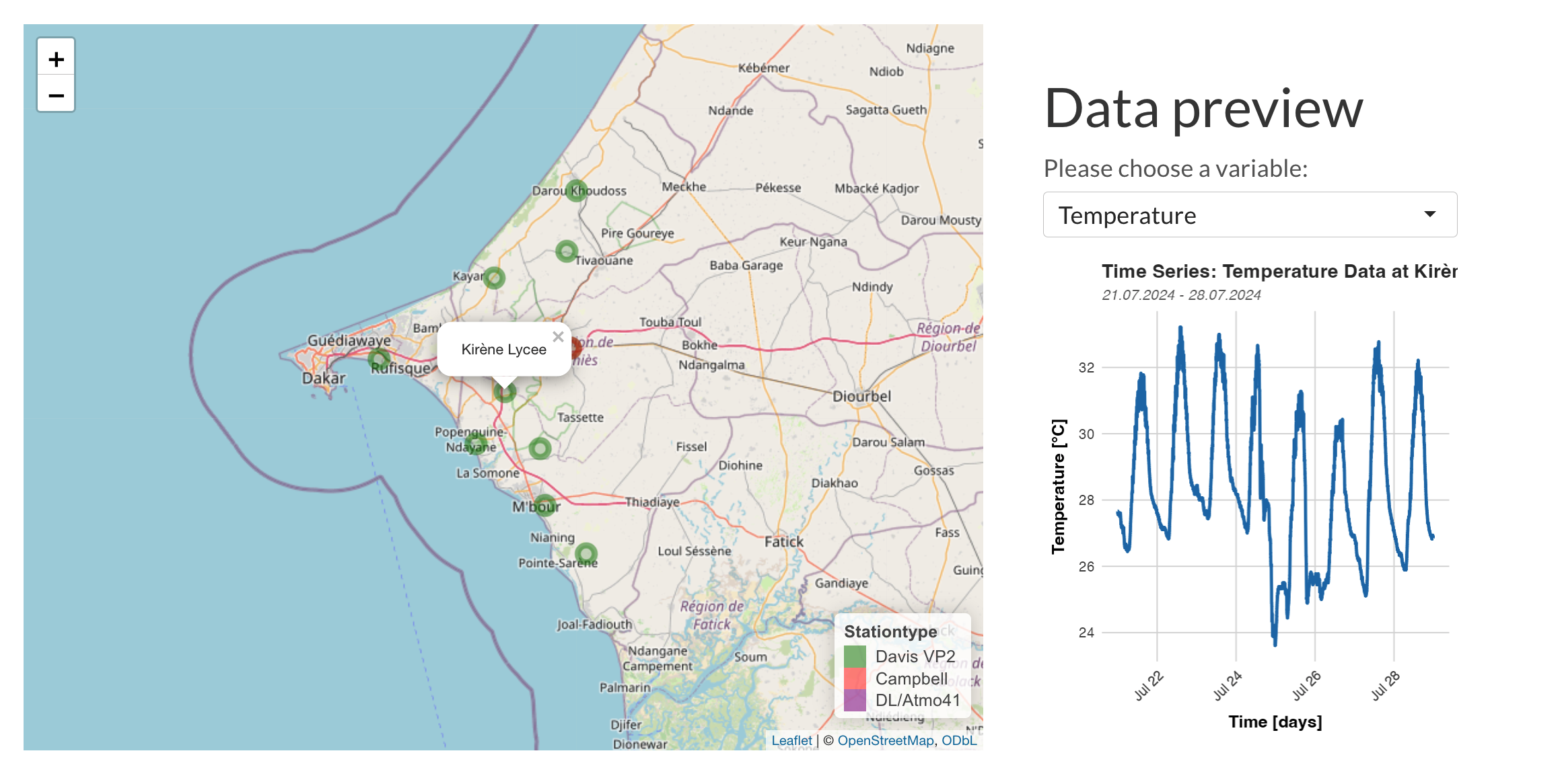
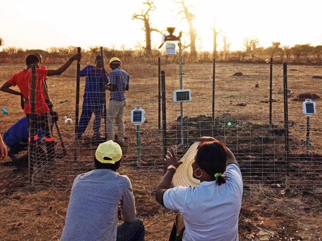
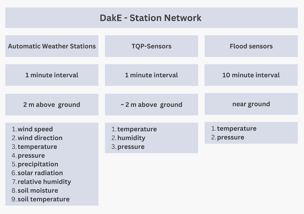
The DakE-station network was designed and built to detect MCS moving towards Dakar. The DakE region extends about 100 km in the meridional direction. It consists of (1) automated weather stations (AWS), (2) small measurement devices recording temperature, pressure and relative humidity, (3) surface pressure sensors to detect flooding and (4) a number of small soil moisture and temperature gauges. For a detailed description of the DakE-Stationnetwork click here. Select the data preview button below to display the AWS station data.
The Team
We are a multidisciplinary team of physicists, meteorologists and environmental scientists. We strongly believe in the value of international collaboration as a means of advancing knowledge and gaining deeper insights. Building on previous research and fostering collaborative efforts to advance scientific understanding is our focus.
Challenges and Motivation
A major challenge to further understand and model the mesoscale convective systems and to predict extreme events is the data scarcity in the study region. Moreover, a general difficulty in predicting flash floods is that they often occur on small spatial (less than 100km) and temporal scales (less than 12h) 1. The DakE project aims to address these gaps by creating a high-resolution observational network east of Dakar to monitor large thunderstorm systems, known as mesoscale convective systems, in near real time. This will help to improve the risk assessment for extreme weather events in the Dakar metropolitan area. Furthermore, the project focuses on understanding the soil-atmosphere feedbacks, the mesoscale convective system interactions and the application and development of nowcasting applications.
References:
1.Schumacher, R. S. (2017). Heavy rainfall and flash flooding. In Oxford research encyclopedia of natural hazard science.
Partner Organizations
The DakE research project would like to thank the partner organisations that have supported the project through their cooperation. Both the Ecole Nationale Supérieure d’Agriculture (ENSA) and the Leibniz-Zentrum für Marine Tropenforschung (ZMT) support the DakE project by making their spatial and online resources available to this day.
Funding
DakE (07/2024 - 12/2025) is funded by the European Research Council’s (ERC) Proof of Concept program, which complements Prof. Härter’s ongoing ERC Consolidator Grant 'Cloud-cloud interaction in convective precipitation (INTERACTION, 2017-2024). This additional funding supports researchers in exploring the societal and commercial applications of their work and helps bridge the gap between research and real-world solutions.


The Station Network
The campaign is building a spatially and temporally high-resolution network of automatic weather stations which are paired with soil moisture measurements and smaller sensors reporting data through the mobile network at a 1-minute interval. To obtain a comprehensive overview of the development of temperature, air pressure and humidity in the entire area, smaller sensors (TQP) were also installed in between the AWS stations, which will later allow interpolation between the AWS-stations.Flood sensors have also been installed in flood-prone areas of the city.
Automatic Weather Stations (AWS)
Until now we installed 14 Automatic Weather Stations (AWS). 12 Davis Vantage Pro 2 stations, 1 Campbell SBs500 station and one Decent Lab/Atmos41 station. The locations of the stations can be found on the Map (below). The stations were set up to the east of the city. This makes it possible to recognize approaching MCS at an early stage and collect data, as the MCS systems approach from the east. The Automated Weather Stations (AWS) record standard meteorological quantities at approximately 2 m above ground at 1-minute time resolution (temperature, relative humidity, wind speed and direction, precipitation, pressure and solar radiation), as well as soil temperature and soil moisture measurements (currently either soil matrix potential, soil permittivity or both, depending on the site) at 10, 20, 40 and 60 cm below the surface at 5-minute time resolution. For power supply the AWS are equipped with solar cells. The data is transferred via the mobile network to a data cloud, at 1 minute temporal resolution, making the data available at near real time at high resolution. Currently, additional seven Campbell-type weather stations are being ordered within DakE and will be deployed in May/June 2025 to increase the existing AWS network to 21 stations. Please select a station on the map and visualize a data preview.
Map created using the leaflet R package. Background map; OpenStreetMap contributors, licensed under the Open Database License (ODbL). Plots generated with the ggplot2 R package.
Interpolation across the Study Area- Small Sensor Network
To enhance the spatial interpolation of the measured data across the entire study area, approximately 100 small measurement devices (type: HumiBaroLog rugged plus) have been strategically deployed in the DakE region. These sensors measure temperature, pressure and humidity in a 1-minute-interval. These devices are powered by long-duration battery and record the data on a build-in memory chip. These devices serve to supplement the AWS by providing higher spatial resolution which may allow to capture cold pool and sea breeze dynamics.
Flood Sensors
In order to determine the duration and extent of the flooding in Dakar, 22 ground-level pressure sensors (type: Hobo) were installed in Dakar. The sensors were installed in the areas most affected by the floods. These waterproof sensors are installed close to the ground and record pressure and temperature with a temporal resolution of 10 minutes. By controlling for air pressure variations, also available from one of our AWS in Dakar, these devices can measure changes in water level (flooding) above ground. Similar to the TQP sensors, these sensors are powered by an internal battery and memory chip.

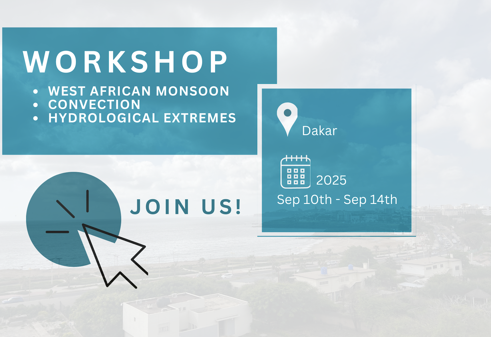
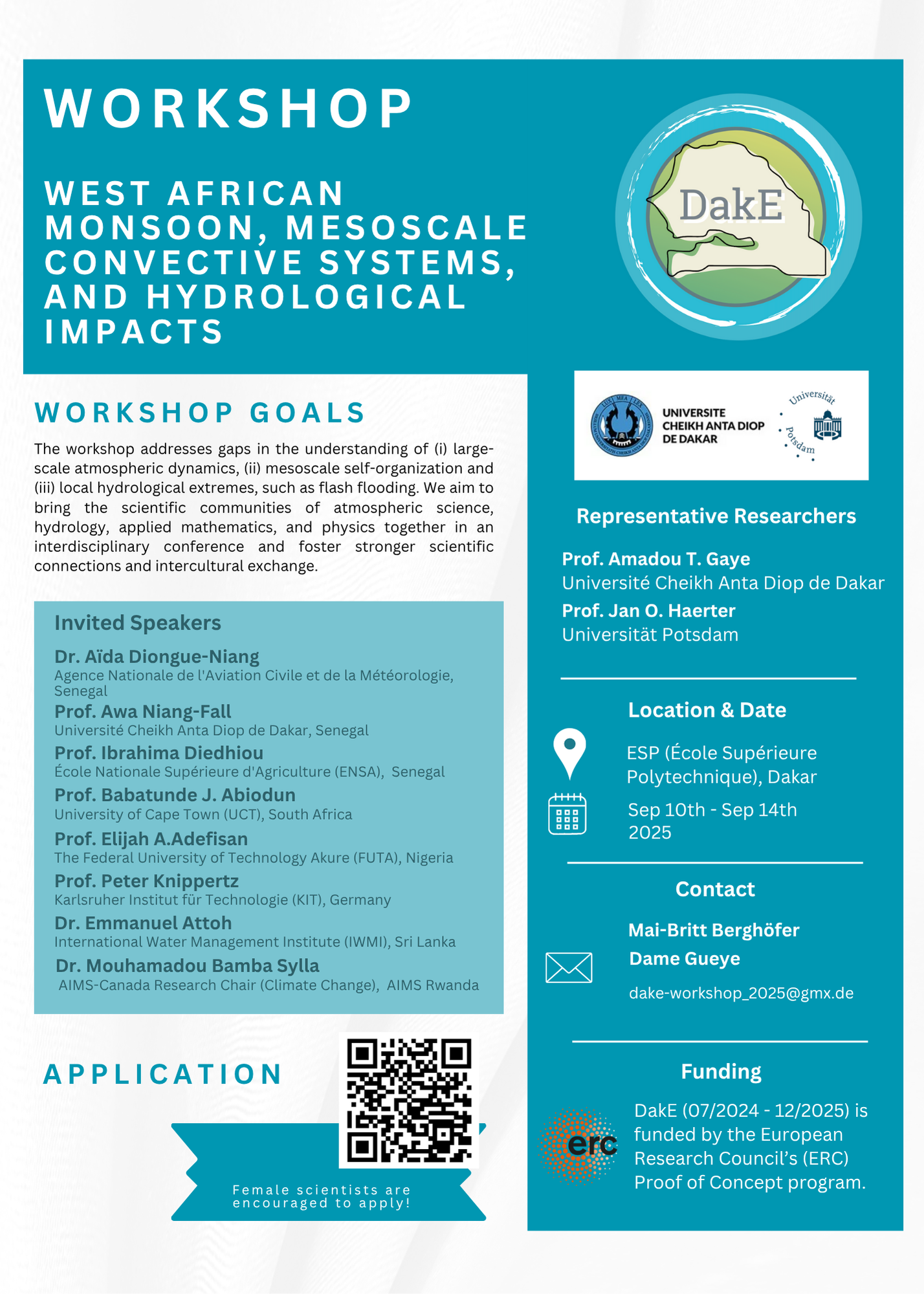
Workshop: West African monsoon, mesoscale convective systems and hydrological impacts
As part of the Dake project, a workshop will be organized, consisting of sessions on the following topics: the West African Monsoon and mesoscale convective systems (MCS), regional climate modeling and atmosphere–land–ocean interactions, hydrological extremes and forecasting, as well as the impacts on agriculture. An outreach day will also be organized afterwards.
Prof. Amadou T. Gaye
Current position : Professor of Climate science and Data analysis at the University Cheikh-Anta-Diop of Dakar (UCAD) of Dakar
Email: atgaye@gmail.com
Research Interests:
- African climate variability and change
- Atmosphere–ocean interactions and teleconnections
- Eastern Atlantic upwelling system dynamics
- Climate–policy interface and stakeholder engagement and research governance
- Adaptation and resilience to extreme climate changes
- West African monsoon dynamics and atmospheric processes

Aissatou Seck
Current position : PhD student at Cheikh Anta Diop University Dakar
Email: aissatou7.seck@ucad.edu.sn
Research Interests:
- Study of extreme weather phenomena (hurricanes, heatwaves, snowstorms, droughts)
- Impact of climate extremes on ecosystems, human populations, and infrastructure
- Modeling and forecasting extreme climate events
- Adaptation and resilience to extreme climate changes
- Effects of extreme climatic variations on biodiversity and natural resources
- Sustainable solutions to mitigate the impacts of extreme weather events
- Energy demand and management in the context of extreme climate conditions

Ashly Wilson
Current position : PHD student at Department of Physics and Astronomy, University of Potsdam
Email: wilson2@unipotsdam.de
Research Interests:
- Dynamics of geophysical flows in the Equatorial region

Yahaya Bashiru
Current position : PhD student at the Department of Physics and Astronomy, University of Potsdam &
PhD Guest student: Complexity and Climate, Leibniz Center for Tropical Marine Research ZMT, Bremen
Email:yahaya.bashiru@uni-potsdam.de / yahaya.bashiru@leibniz-zmt.de
Research Interests:
- Land-atmosphere interaction
- Soil moisture dynamics and interaction with mesoscale convective systems
- Deep convection
- Numerical modelling
- Tropical meteorology
Dr. Cheikh Modou Noreyni Fall
Current Position: Postdoc at Cheikh Anta Diop University Dakar
Email: mcheikhmodou.fall@ucad.edu.sn
Research Interests:
- Influence of extreme wet and dry rainfall events (dry/wet Spells ) on crop yields in Senegal
- Ability of remote sensing, reanalysis and in situ data products to detect these potentially high-impact events
- Strengthening the resilience of vulnerable communities and protecting ecosystems
- Understanding climate suitability of Senegalese agricultural systems

Dame Gueye
Current position : PhD student at Cheikh Anta Diop University Dakar
Email: gueye.dame2@ugb.edu.sn
Research Interests:
- Study of ocean physical processes
- Impact of extreme weather events
- Climate modeling
- Climate variability
- Atmospheric physics

Diana L. Monroy
Current position : PHD student at Department of Physics and Astronomy, University of Potsdam
Email: diana.monroy@uni-potsdam.de
Research Interests:
- Precipitation and flood nowcasting for Dakar

Prof. Jan O. Haerter
Current position : Professor of computational and climate physics at Department of Physics and Astronomy
at the University of Potsdam
Email: jan.haerter@uni-potsdam.de
Research Interests:
- Computational and climate physics
- Complex Systems
- Atmospheric complexity and moist convection
Jean Didier Gati-Mounga
Current position : PHD student at LPAO-SF/ ESP / UCAD
Email: dgatimounga@gmail.com
Research Interests:
- Convective systems
Prof. Ibrahima Diedhiou
Current position : Département Productions Végétales Ecole Nationale Supérieure d’Agriculture (ENSA)
Email: idiedhiou@ensa.edu.sn/ibrahima_diedhiou@hotmail.com
Research Interests:
- Land restoration: Research on the role of shrubs and trees in soil regeneration and sustainable agricultural production
Karoline Kny
Current Position: Master Student in Geoecology at the University of Potsdam
Email: karoline.kny@freenet.de
Research Interests:
- Influence of soil properties on heat fluxes
Dr. Katya Dimitrova Petrova
Current Position: Postdoctoral researcher in Subsurface Hydrology at the University of Potsdam
Email: katya.dimitrova.petrova@uni-potsdam.de
Research Interests:
- Influence of soil properties on heat fluxes
- Capturing soil moisture dynamics
- Interest in field observation techniques
- Application in environmental modeling
- Click here for more information
Ludovica Gatti
Current Position: Master student in Climate, Earth, Water and Sustainability Program at the University of Potsdam
Email: ludovica.gatti.1@uni-potsdam.de
Research Interests:
- Cold pool dynamics and interaction
- Deep convection
- Self aggregation of convection

Mai-Britt Berghöfer
Current Position: Master student in Climate, Earth, Water and Sustainability Program at the University of Potsdam
Email: berghoefer@uni-potsdam.de
Research Interests:
- Nowcasting precipitation and extreme events
- Forecasting and detecting floods and droughts
Dr. Maxime Colin
Current Position: Postdoc at Leibniz Center for Tropical Marine Research ZMT, Bremen
Email: maxime.colin@leibniz-zmt.de
Research Interests:
- Deep convection
- Tropical meteorology
- Phase changes and microphysics
- Convection-circulation coupling
- Monsoons, climate modes, El Niño, water cycle, memory

Dr. Nicolas Da Silva
Current Position: Postdoc at Department of Physics and Astronomy, University of Potsdam
Email: nicolas.da.silva@uni-potsdam.de
Research Interests:
- Temperature-precipitation extremes relationship
- Mesoscale convective systems
- Influence of soil properties on heat fluxes and mesoscale convective systems

Salif Diedhiou
Current Position: PhD student at Cheikh Anta Diop University Dakar
Email: diedhiousalif3@gmail.com
Research Interests:
- Hydrological modeling
- Extreme rainfall analysis
- Flood risk assessment
- Impacts of climate variability in West Africa
We would like to thank our Partners:

Dame Gueye
Contact for: Station maintenance questions, Workshop
Email: gueye.dame2@ugb.edu.sn
Prof. Jan O. Haerter
Contact for: Research collaborations, Research Interests
Email: jan.haerter@uni-potsdam.de